Land surveying is the measured description of land and the features on it, recording where things are in three dimensions so that positions, levels, areas and boundaries can be set down accurately. A surveyor uses precise instruments and a known reference framework to turn the physical world into coordinates, drawings and digital models that designers, builders, planners and lawyers can rely on.

What is land surveying?
At its core, land surveying answers a simple question with great precision: where is this point, relative to other points and to a fixed reference? Everything else — boundaries, contours, building footprints, drainage levels — follows from accurately located points. The discipline combines fieldwork (taking measurements on site) with office work (processing those measurements into usable outputs).
The work matters because decisions about land carry real consequences. A new building must sit within a legal boundary and meet the surrounding ground at the right levels. A road must follow gradients that drain and stay within tolerances. A flood model needs accurate ground heights. In each case, errors measured in centimetres can have costs measured in much larger sums, which is why surveyors work to defined accuracies and document how those accuracies were achieved.
Land surveying overlaps with several related fields. Geomatics is the broader term covering the gathering, processing and management of spatial data. Geodesy deals with the size and shape of the Earth and underpins national coordinate systems. Hydrographic surveying measures water-covered areas. Most general practice on UK sites, however, concerns the land surface and the structures on it.
The main types of survey at a glance
At its core, land surveying answers a simple question with great precision: where is this point, relative to other points and to a fixed reference?
"Survey" is a broad word, and the type required depends entirely on the question being asked. The common categories are distinct, though one project may need several of them.
- Topographic (or measured land) survey — a detailed record of an area's surface features: ground levels, kerbs, manholes, trees, buildings, fences and the like. This is the base map most designers start from. It is usually delivered as a scaled drawing and a digital model.
- Measured building survey — accurate plans, elevations and sections of a structure, inside and out. Used by architects and for refurbishment, extension or change-of-use work.
- Boundary survey — investigation of where a legal boundary lies, drawing on title plans, physical evidence on the ground and survey measurement. Useful for disputes, sales and development near a boundary line. The legal boundary and the physical features rarely coincide exactly, so interpretation is part of the task.
- Setting-out survey — the reverse of recording: marking out design positions on the ground so that construction follows the drawings. A surveyor transfers coordinates from a plan to physical pegs, lines and levels.
- Engineering and monitoring survey — high-precision measurement during construction, and repeated observation of structures or ground to detect movement over time.
- Utility survey — locating buried services such as cables and pipes, typically combining records, electromagnetic detection and ground-penetrating radar.
- Geospatial mapping and GIS data — larger-area capture, increasingly from aerial or drone platforms, feeding into geographic information systems.
These types connect through their shared framework. A topographic survey often establishes the control that a later setting-out survey reuses, so the design ties back to the same reference as the original measurements. Asking which output you actually need — a drawing, a model, a legal opinion, marked pegs on site — is the quickest way to identify the right survey.
Instruments and how positions are measured
Two technologies dominate modern fieldwork, and they are usually combined rather than chosen between.
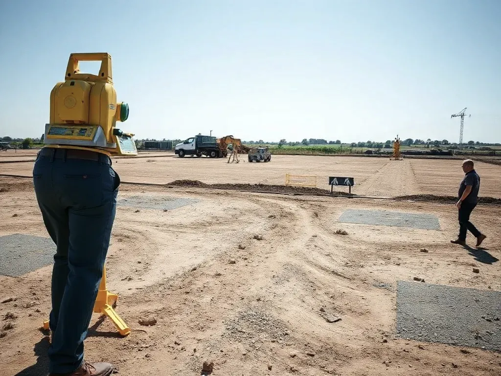
The total station is the workhorse of detailed ground survey. It is an electronic instrument that measures both the angle to a target and the distance to it, then computes the target's position. The distance is found by timing or analysing a beam of light sent to a reflector (a prism) or, on reflectorless models, directly to a surface. Set up over a known point, a total station can record hundreds of detailed features quickly and to a few millimetres of precision, which makes it well suited to topographic and engineering work where local accuracy matters most.
GNSS positioning uses satellites to fix a position on the Earth's surface. GNSS stands for Global Navigation Satellite Systems, the family that includes the American GPS, the European Galileo and others. A survey-grade GNSS receiver achieves far better than the metre-level accuracy of a phone, often a couple of centimetres, by using correction data and comparing signals against a reference. It excels over open ground and large areas, where it can establish positions without a clear line of sight between points. Under tree cover or among tall buildings, where satellite signals are blocked, a total station usually takes over. Many surveyors carry both and switch as conditions demand.
Whatever the instrument, the measurements mean little without a framework to hang them on, and that is the role of the survey datum and control. A datum is the agreed reference from which positions and heights are counted. In Great Britain, horizontal positions commonly relate to the Ordnance Survey National Grid, and heights to Ordnance Datum Newlyn, which sets zero at mean sea level measured at Newlyn in Cornwall. "Control" is a network of carefully fixed points — physical marks or precisely known coordinates — that the rest of a survey is measured from. Establishing good control first means every later measurement shares the same reference, so different surveys of the same site agree and can be combined.
Laser scanning is an increasingly common addition. A scanner sweeps a laser across surroundings to capture millions of points — a "point cloud" — which can be turned into detailed models of buildings, structures or complex sites. Drones extend this from the air, producing imagery and elevation data over wider areas. Both still depend on the same principles: known instruments, known datum, and control points that tie the captured data to the ground with measurable accuracy.
Understanding these foundations helps when commissioning work. Knowing the question you need answered, the type of survey that answers it, and the accuracy and datum the result will be tied to are the points worth clarifying with any surveyor before fieldwork begins.

Reviewed: June 2026